Mass digitization of spatial data

Mass digitization is one of the approaches for large spatial data sets acquisition. Usually, a lot of people are involved in such project, thus a handful and efficient tools for digitization, which are highly adapted for the given task, can save a lot of time and more importantly, minimize the possibility for human errors in the acquired data. Additionally, a good managing of work and efficient quality control (QC) are crucial to ensure the success of the project.
With all this in mind, we developed the set of tools for mass digitization. The software supports all three important aspects of mass digitization projects:
-
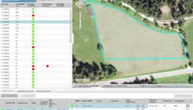
MANAGING AND MONITORING of the work on a project: The work can be split in smaller packages by spatially dividing the area of acquisition into blocks. The work within each block is then assigned to one operator. The workload for single operator can be managed by adjusting the size of block and by the assigning different number of blocks.
The statuses of the blocks (e.g., assigned, in process, completed) are color-coded and shown on the map, what enable a quick estimate of the work already done. Due to the convenience and simplicity of use of the viewer, it is possible to manage and keep good overview for wide areas.
Monitoring of the system’s performance enables user to find the problematic spots quickly. The system reports the errors and problems on-the- fly and it keeps the statistic of the performance. This can be used for calculation of different indicators based on which the efficiency and quality of the work of operators can be evaluated.
-
DIGITALIZATION: We are able to adapt our software for a specific needs of different projects. The access can be limited to the tools that are needed to perform the task at hand. As a consequence, even less experienced operators can be relatively quickly taught how to use the tools and reach a high performance. Some of the functionalities of our tools that have proved to be most useful for operators are:
- Topology supported editing preventing technical errors on neighbouring areas
- Quality assurance business rules preventing input errors, both on spatial and alpha-numerical data
- Minimized number of clicks needed to perform the task
- Displaying the map in convenient scale and with convenient focus
- Keyboard shortcuts
-
QUALITY CONTROL (QC):The work of the operators can be controlled using the special module for Quality control. Some of the most useful functionalities of QC module are:
- Displaying the map in convenient scale and with convenient focus
- Configurable % of the blocks that need to be controlled for each operator separately; the % can be lower with less risk for the operators with the good previous results of QC.
- Pre-prepared comments for the most common errors.
See the example of use in the video below.